 |
|
Cruise Ship Route - Ketchikan to Juneau |
|
 |
||||||||||||||||
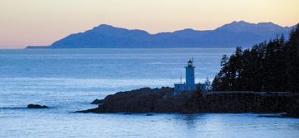
Most Northbound big cruise ships leave Ketchikan around 2 so as to make it to either Juneau or the Tracy Arm area the next morning. Just north of downtown, you’ll pass the airport on the left along with the little ferry that runs back and forth. Before the airport was built in 1973 travelers had to use the old Air Force airport at Annete Island, 25 miles south, with big ex-Navy PBY’s to shuttle you over. These planes were pretty old and leaked along the riveted seams and travelers told of water running back along the floor of the plane when they accelerated for takeoff! This is also the site of the proposed ‘Bridge to Nowhere’ - a controversial bridge project that was called a boondoggle in 2007-8 and finally cancelled. In order to be high enough for cruise ships to pass underneath it had to follow a circuitious route, across the channel from south Ketchikan to Pennock Island and finally to Gravina where the airport is located. Look to the right a little north of the airport and you’ll see big Wards Cove with an old cannery on the right and what’s left of the old Ketchikan Pulp mill further in. The mill was the main economic engine in town for almost 50 years, a period in during which the mill had so much power in town that at times it had seemed that commercial fishermen were almost second class citizens. But by the 1970s there was a growing awareness that some logging practises, like driving bulldozers down the middle of salmon streams were damaging to salmon habitat and commercial fishermen’s groups raised a growing opposition. At the time I was a salmon fishermen living in a remote town and right in the middle of the controversy. At one meeting when Forest Service and pulpmill representatives flew into Port Protection to meet with us, we greeted them by singing Paradise, a song originally written about the havoc coal mines played with the West Virginia landscape. At the meeting our complaints were brushed aside, and if someone had told me then that the mill would close two decades later because of tougher logging regulations, I would have laughed in disbelief. But that is exactly what happened - the enviromental pendulum swung the other way, logging and pollution regulations were tightened, and in 1997, the mill was closed, and the Ketchikan economy became much more dependent on seasonal jobs related to the cruise ship boom. Guard Island lighthouse is on the left at Mile 664 and then your ship passes into wide Clarence Strait, one of the main north-south channels in Southeast Alaska, with the mainland on the right and Prince of Wales Island on the left. Prince of Wales, POW locally, is the fourth largest island in the US, behind Hawai’i, Kodiak, and Puerto Rico, and when the pulp mill was operating, was basically the grand prix of US logging, with several big logging camps, including the big floating camp at Thorne Bay. Today logging is mostly conducted on native owned land here, and as the old logging roads are slowly getting paved the regular ferry from Ketchikan is bringing more and more vacationers to POW with campers and RVs and communities like Coffman Cove that used to be logging camps are becoming communities of vacation and second homes. On the right at Mile 685 is Meyers Chuck, or just “The Chuck”to locals, one of those roadless fishing communities that retains the flavor of what Southeast used to be like. With a few dozen homes scattered around the sheltered harbor, commercial salmon fishing with a gillnet area right in front, pretty much drives the local economy. You’ll want to be up and looking around when your ship goes through narrow Snow Pass at mile 720, about four hours after leaving Ketchikan. The tide swirls in this narrow channel tends to bring schools of herring to the surface, which is why this is a good place to look for humpback whales. If you have never seeen one, just look for what looks like a puff of smoke, which is a humpback exhaling as it comes up, and can be seen from over a mile away. You will pass a red buoy on the right of your ship going through, and usually there is at least one lazy fat sea lion sleeping on it. After Snow Pass you’ll swing west into Sumner Strait, following the Prince of Wales shore. Ships bound for Petersburg, and Wrangell, two towns that are seldom visited by cruise ships - Petersburg likes it that way, but Wrangell hopes the big boys will come - will swing off to the northeast here. Wrangell Narrows, a twisting 22 mile channel is hidden in the hills to the north here. It's too shallow and narrow for big cruise ships, but everyone else up to 400' Alaska ferries take it, as it saves about 75 miles between Ketchikan and Juneau. Look for salmon gillnetters operating in both Clarence and Sumner Straits. They set their 1800 long nets like fences in the water, with the thin nylon meshes held up by hard foam corks and down by leads. The nets are about 25’ deep and pretty much just catch salmon and the occasional dogfish. This is a good fishery for couples and small families You'll probably see some signs of life at mile 742, as you pass the northern tip of Prince of Wales Island. These are the roadless communities of Port Protection and Point Baker, with about 7o folks in each. Your mapmaker built a cabin here in the 70s and wrote about those days in his classic book, Alaska Blues. The community center was the floating bar - the bartender was also the fish buyer - you could come, unload, and sell your fish for bar credit! Make sure you stay up long enough to watch off to the starboard or right side of your ship as you swing around the Cape Decision lighthouse and up into wide Chatham Strait. For most northbound ships this will be about 7-8 hours after leaving Ketchikan. For much of the 20th century, Chatham Strait was a beehive of activity. Between the salmon plants, the herring plants, and the whaling stations, almost every bay in this canyon-like region was home to some sort of commercial activity, frenzied during the summer fishing season, and sleepier in winter, with usually just a caretaker and his family keeping a watch on things. Then the herring and the whales disappeared, and refrigerated tenders allowed consolidation of the salmon canneries into towns like Petersburg and Ketchikan. For the small craft traveler today, it is almost spooky to travel in Chatham Strait, to anchor and go ashore and wander in the ruins, rarely encountering another traveler. One of the few settlements along here is Port Alexander, Mile 792. With a good harbor, a settlement, a fish buyer and a store, and good fishing at Cape Ommaney (west of mile 786), it’s a popular spot in summer. In its heyday, the 1920s and 1930s, it was an exciting place: “It became the number one trolling port in the territory, a wide-open, carefree, money-kissed little place that old-timers still recall with nostalgia.” —John Joseph Ryan, The Maggie Murphy When they walked into town, they were halted by an elderly man who told them, “Boys, it’s illegal to walk on the streets of Port Alexander sober.” In those days, many trollers worked out of open boats, some without motors, rowing as they towed their lines through the water. A little tent city sprang up south of the dock each summer. But by the late 1940s the party was over. The great runs rapidly diminished as the newly-built dams on the Columbia River, 1,200 miles south, prevented the big kings from reaching their spawning grounds. At Port Conclusion, three miles north of Port Alexander, Vancouver anxiously awaited the four overdue cutters and yawl boats that were filling in the last blank places on his chart in August, 1794. Finally the boats hove safely into sight during a rainstorm on the 19th. Then with grog for all hands, and cheers ringing from ship to ship in a remote cove halfway around the world from England, there ended one of the most remarkable feats of navigation and exploration in modern times. In three summers of exploring and charting this unknown coast, through persistent fogs, swift currents and occasional thick ice— losing just one man to bad shellfish— Vancouver had disproved the ages-old notion of a Northwest Passage back to the Atlantic. In doing so, he charted, explored, described and named much of the Northwest coast. It was nothing less than a stunning achievement. He was 38 years old. The village visible to the southeast from mile 845 is Kake, a Tlingit village supported by a cannery and logging on native land. Locals use narrow Rocky Pass frequently as a short cut to Sumner Strait. According to one story they were astounded a few years back, to see a tug towing a big barge emerging from the constricted passage. No one could remember such a big vessel or barge coming through the pass before. The skipper stepped out and hailed some locals fishing from a skiff: “Say,” the rough-looking man said, waving a hand back toward Rocky Pass, “that Wrangell Narrows ain’t nothing like the chart.” He stopped and looked over at the village on the shore, “And I thought Petersburg was larger than this.” He was 40 miles west of where he thought he was! |
||||||||||||||||
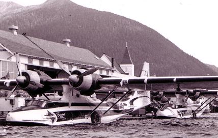
Ketchikan airport shuttle, 1965. The old Navy PBY's were refitted with seats to fly passengers from the Ketchikan waterfront to the airport 25 miles away on Annette Island. The rivets leaked, and if the plane sat the water too long before takeoff, water would run down the aisles when the pilot throttled up! Now folks take the ferry to the new airport right across the channel. The infamous "Bridge to Nowhere' would have crossed the channel south of downtown. |
||||||||||||||||
 |
||||||||||||||||
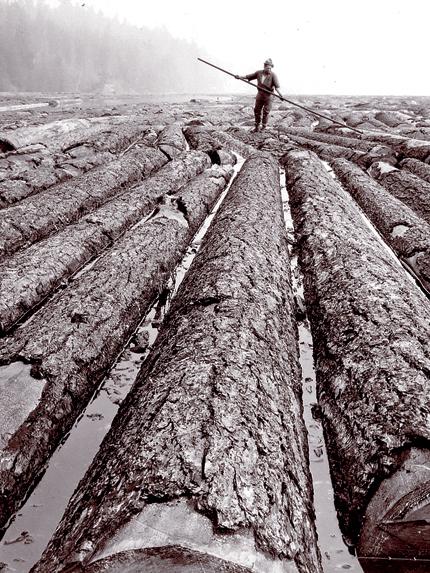
By the mill - logging and millwork were the big employers in Ketchikan and Sitka for almost 40 years. But by the turn of the century, both mills closed rather than comply with stricter pollution and logging standards. |
||||||||||||||||
 |
||||||||||||||||
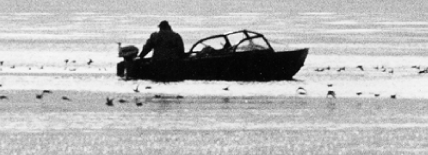
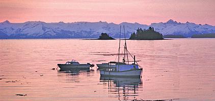
Skiff fisherman near Meyers Chuck, one of those roadless communities with a fish buyer, and good fishing right out the harbor mouth. Want to try it? Here's a waterfront house with a dock: http://www.meyerschuckhome.com |
||||||||||||||||
 |
||||||||||||||||
Don't miss Snow Pass - about 4 hours north of Ketchikan - a good spot to look for whales as well as the big sea lion that often hangs out on the buoy on the right hand side of the channel. |
||||||||||||||||
 |
||||||||||||||||
You'll be passing through gillnet areas this afternoon and evening. It's a good fishery for couples, and some fish with their children. The nets are 1800' long, 25' deep, and rarely catch anything but salmon and the occasional dogfish. |
||||||||||||||||
 |
||||||||||||||||
Cape Decision, at Mile 775, is a major turning point on this leg. You'll swing around to the right and enter Chatham Strait and swing east to Stephens Passage in the middle of the night. |
||||||||||||||||
 |
||||||||||||||||
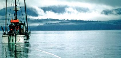
The shores of Chatham Strait are full of protected coves and bays. This salmon boat is coming out of Big Port Walter, on the west at about Mile 805. The winding passage opens to a bay with an abandoned herring plant. When herring fishing was in full swing here in the 1940s, the Standard Oil Tanker used to go up this narrow channel! |
||||||||||||||||
 |
||||||||||||||||
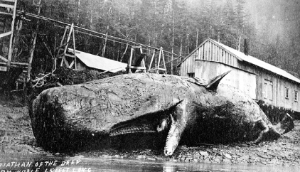
Almost every bay here had some sort of fish processing facility in it at some time during the 1900s. This is a sperm whale at Port Armstrong, Mile 800. Today almost all these bays are empty with just ruins on the beach as fish processing has moved to towns like Petersburg, where processors don't have to build and maintain a whole town. |
||||||||||||||||
 |
||||||||||||||||
This is the view looking west from the native village of Kake, Mile 845. That is Baranof Island in the distance, looking like a mountain range rising from Chatham Strait. |
||||||||||||||||
 |
||||||||||||||||
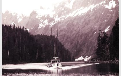
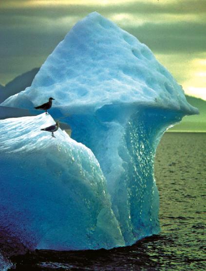
Look for icebergs in Stephens Passage. This is the southern limit of drift ice from the glaciers in Tracy and Endicott Arms, east of Mile 900, and Le Conte Glacier, east of Petersburg. In the 70s and 80s when I was running fishing buying boats and gillnetting in this area, ice was a big hazard. It dosen't’t take much of an iceberg to puncture the hull of a fiberglass or wooden fishing boat. Plus ice is not very buoyant so an iceberg the size of a dump truck would hardly show above the surface of the water, and be almost impossible to see on radar if there was any kind of a choppy sea running or a swell driving up from the Gulf of Alaska. So boats would travel very cautiously in these waters if visibility was poor. The icebergs did have benefits though. When I was a fish buyer, trying to save time and fuel on the long run up to Chilkat Inlet in Lynn Canal, Mile 1000N, we’d pull up as close as we could to the biggest iceberg we could find - tie right to it if it was calm - and turn on our pumps and suck the cold water right around the iceberg into our big insulated fish hold and thus save hours of running the noisy refrigeration system! |
||